Zoom
 Pan
Pan
Traverse County, MN Wall Map
In Stock
by MarketMAPS

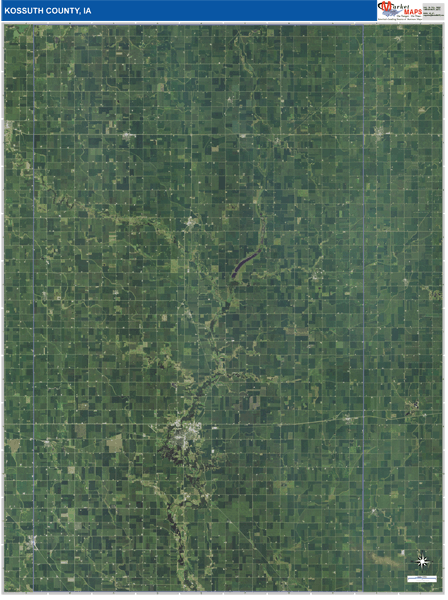
The Satellite Pure Style Wall Map gives you a bird's eye view of your area without distractions. The display on this style is very clear with no overlaid map detail. It is an excellent map for drawing locations, territories and other information on your map.
People purchase Traverse County Wall Map, choose the Pure Satellite Style because:
- - Map details are easy to see such as lakes, rivers, developments, property divisions and mountains.
- - The Traverse Wall Map is laminated and compatible with dry erase markers.
- - Businesses can use it for reference or planning.
Your Selection:
Size:
36 x 48"
Unit Price:
$125
Finishing Option:
Laminated
In Stock
Your Options
Available Map Sizes
Delivered as FAST as Next Day!


Available Finishing Options

36 x 48"
48 x 64"
60 x 80"
72 x 96"
90 x 120"
108 x 144"
Laminated Map
Selected
Select
Select
Select
Select
Select
...with Wooden Rails
Select
Select
Select
Select
Select
Select
...Mounted Maps
Select
Select
Select
Select

...Magnetic Maps
Select
Select
Select
Select
Looking for other Finishing Options?
ReStickersBasic FramedExec. FramedPlastic RailsSynthetic Maps
Other Wall Map Finishing Options
ReStickers
Select
Select
Select
Unfinished
...Basic Framed
Select
Select
Select
Select
Dark Oak
...Executive Framed
Select
Select
Select
Select
...Plastic Rails
Select
Select
Select
Select
Select
Paper Maps
Select
Select
Select
Synthetic Maps
Select
Select
X
Item Successfully Added to Your Cart
Traverse County, MN Wall Map
$85.00
Satellite Pure Style 2026
MarketMAPS
Qty: 1