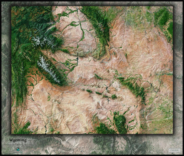
Wyoming Satellite Wall Map
This Wyoming Satellite Map spectacularly displays the "Equality/Cowboy State" as it's seen from outer space. This striking aerial view map was created from spectral data obtained from NASA's Landsat satellites which was then combined with 3-D shading to provide a natural looking satellite map that has three dimensional depth which helps to distinguish terrain much more than the "flat" satellite maps you've seen. Being one of the most mountainous states in America, the state of Wyoming looks amazing in this satellite map which accentuates the many mountain ranges, deserts, plains, canyons, and other unique landforms and overall rugged beauty. Specific natural features of Wyoming such as the Big Horn Mountains, Wind River Range, Grand Tetons, Great Divide Basin, and the Yellowstone plateau all show up vividly in the map. This gorgeous Wyoming Satellite Map is incredibly detailed too: each pixel of resolution in the printed map represents 162 ft (49 meters)! This super high level of resolution allows identification of urban cities and towns, crop fields (including circular irrigated fields), rivers, major super highways, lakes, and even large parks within cities. You'll see more details on large sized maps, so we recommend ordering the largest map that will fit on your wall. Labels were intentionally omitted to create a pure, uncluttered look. This sensational satellite image is guaranteed to provide hours of enjoyment as you explore all the natural and man-made wonder visible in this Wyoming satellite map. This Wyoming Satellite Wall Map includes the following features:
- High resolution satellite imagery: 1 printed pixel represents just 162 ft (49 m)
- Sleek shading of Wyoming's outline
- Three dimensional shaded relief
- Legend with scale bar
- Clear visibility of cities, roads, parks, rivers, fields of agriculture, and much more
The Wall Map of Wyoming Satellite is printed on 24lb. premium coated bond paper. It is also laminated on both sides using 3mm hot lamination, which protects your wall map and allows you to write on it with dry-erase markers.


Outlook Maps
Qty: 1