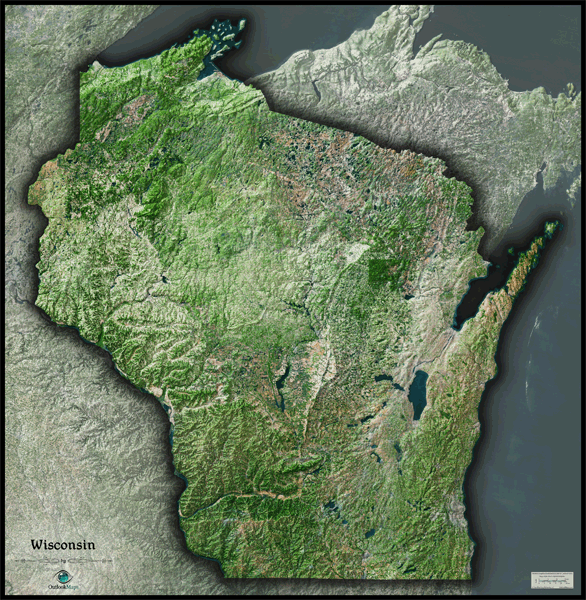
Wisconsin Satellite Wall Map
This Wisconsin Satellite Map dramatically displays the "Badger State" as seen from outer space. The stunning aerial image was created from spectral data (satellite image data) taken from NASA's Landsat satellites which was then combined with 3D shading of the landscape. This provides a vivid, natural looking satellite map that has three-dimensional depth helping to visualize Wisconsin's terrain much more than the "flat" satellite maps you've seen before. Wisconsin's diverse and unique landscape looks especially cool when viewed from space. The rugged terrain is colorful and unlike any other state's, while Wisconsin's thousands of lakes are clearly visible. Distinguishing between natural forested areas, agriculture, and urban development is very easy throughout the map. This beautiful Wisconsin Satellite Map is also extremely detailed: each pixel of resolution in the map is equal to just 146 ft (44 meters)! This high resolution allows identification of urban cities, small towns, crop fields, rivers, major roads, ponds, airports, and even large parks within cities. You'll see details more clearly on large sized maps, so we recommend ordering the largest map that will fit on your wall. Labels were left off to create a satellite image that has a pure and uncluttered appearance. This spectacular satellite image is guaranteed to provide hours of enjoyment as you explore all the natural and man-made wonder visible in this Wisconsin satellite map. This Wisconsin Satellite Wall Map features the following:
- High resolution satellite imagery: 1 printed pixel represents just 146 ft (44 m)
- Sleek shading of Wisconsin's outline
- Three dimensional shaded relief
- Legend with scale bar
- Clear visibility of cities, roads, rivers, parks, individual crop fields, and much more
The Wall Map of Wisconsin Satellite is printed on 24lb. premium coated bond paper. It is also laminated on both sides using 3mm hot lamination, which protects your wall map and allows you to write on it with dry-erase markers.


Outlook Maps
Qty: 1