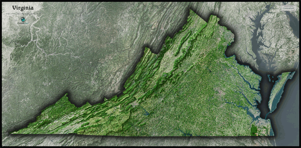
Virginia Satellite Wall Map
This Virginia Satellite Map dramatically displays the "Old Dominion" as seen from outer space. The striking aerial image was created from spectral data obtained from NASA's Landsat satellites which was then combined with 3D shading of the landscape. This provides a natural looking satellite map that has three dimensional depth helping to make out Virginia's terrain much more than the "flat" satellite maps you've seen before. The extreme variety of Virginia's landscape makes it an especially interesting state when viewed from space. The contrast between the coastal plains in the east to the flat farmland in the center to the rugged Appalachian Mountains in the west is very prominent. It's very easy to distinguish natural and wooded areas in the map from developed urban and agriculture areas. This gorgeous Virginia Satellite Map is extremely detailed too: each pixel of resolution in the printed map represents just 147 ft (45 meters)! This high level of resolution allows for clear identification of urban cities, small towns, crop fields, rivers, major roads, ponds, airports, and even large parks within cities. You'll see more details on large sized maps, so we recommend ordering the largest map which can fit on your wall. Map labels were left off of the map so the satellite image appears more pure and uncluttered. This spectacular satellite image will definitely provide hours of enjoyment as you explore all the natural and man made wonder visible in this Virginia satellite map. This Virginia Satellite Wall Map features the following:
- High resolution satellite imagery: 1 printed pixel represents just 147 ft (45 m)
- Sleek shading of Virginia's outline
- Three dimensional shaded relief
- Legend with scale bar
- Clear visibility of cities, roads, rivers, parks, fields of agriculture, and much more
The Wall Map of Virginia Satellite is printed on 24lb. premium coated bond paper. It is also laminated on both sides using 3mm hot lamination, which protects your wall map and allows you to write on it with dry-erase markers.


Outlook Maps
Qty: 1