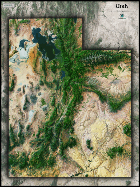
Utah Satellite Wall Map
This Utah Satellite Map dramatically displays the "Beehive State" as it's seen from outer space. The striking aerial view map was created from spectral data obtained from NASA's Landsat satellites which was then combined with 3-D shading to provide a natural looking satellite map that has 3 dimensional depth which helps to make out natural terrain much more than the "flat" satellite maps you've seen before. The map really accentuates Utah's unique landforms, canyons, mountain ranges, deserts, valleys, plateaus, and overall rugged beauty. Perhaps no state looks as cool from space as Utah. Specific features like the Great Salt Lake, Great Salt Lake Desert, Wasatch Range, Uinta Mountains, and the Colorado River are all clearly visible in the map. This gorgeous Utah Satellite Map is extremely detailed too: each pixel of resolution in the printed map equates to just 153 ft (47 meters)! This high resolution allows identification of urban cities and towns, crop fields, rivers, major highways, lakes, airports, and even large parks within cities. You'll see more details on large sized maps, so we recommend ordering the largest map which can fit on your wall. Labels were left off to create a satellite image that has a pure and uncluttered appearance. This spectacular satellite image is guaranteed to provide hours of enjoyment as you explore all the natural and man-made wonder visible in this Utah satellite map. This Utah Satellite Wall Map features the following:
- High resolution satellite imagery: 1 printed pixel represents just 153 ft (47 m)
- Sleek shading of Utah's state outline
- Three dimensional shaded relief
- Legend with scale bar
- Clear visibility of cities, roads, rivers, parks, crop fields, and more
The Wall Map of Utah Satellite is printed on 24lb. premium coated bond paper. It is also laminated on both sides using 3mm hot lamination, which protects your wall map and allows you to write on it with dry-erase markers.


Outlook Maps
Qty: 1