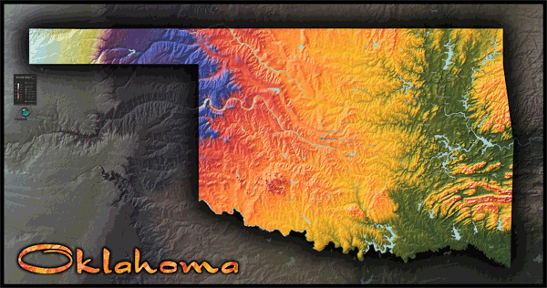
Oklahoma Topo Wall Map
This extraordinary map art displays the geography of the state of Oklahoma in a unique and colorful topographical style like you've never seen before: a combination of an Oklahoma reference map, Oklahoma physical map, and an artistic Oklahoma poster. The sensational topographical image of the map was created by using digital elevation data to produce a 3-D model of Oklahoma's terrain. The landscape is then colored according to elevation. The result is a stunning colorful image of Oklahoma that is completely accurate and incredibly detailed - even the smallest of hills and valleys are clearly visible. Though Oklahoma is a vast state in the great plains, the subtle topography comes to life in this style of map which customizes the color range specifically for Oklahoma's elevation range. The gradual increase of elevation from East to West is very pronounced. Specific natural features of Oklahoma, such as the Ozark Plateau, Ouachita Mountains, Arbuckle Mountains, Wichita Mountains, and High Plains in the west, are all clearly visible in this map. The map, while primarily a visual physical map, also includes the major towns and cities of Oklahoma - adding usefulness to the map without cluttering it or detracting from Oklahoma's physical beauty. Whether you're looking for a piece of map art or an Oklahoma reference map, this Oklahoma map poster fits the bill and will look spectacular when displayed on your wall. Many other states and countries are also offered in this same map style. This map includes the following features:
- Topographical coloration of terrain
- Scale which matches color to corresponding elevation values
- Three-dimensional shaded relief
- Oklahoma cities and towns with population greater than 5000 (source: 2010 census)
- Legend
- Note: The purpose of this map is to provide a visual representation of Oklahoma's topography and landscape. In order to maintain a clean and uncluttered image, map detail is limited to towns and cities only.
The Wall Map of Oklahoma Topo is printed on 24lb. premium coated bond paper. It is also laminated on both sides using 3mm hot lamination, which protects your wall map and allows you to write on it with dry-erase markers.


Outlook Maps
Qty: 1