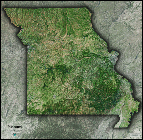
Missouri Satellite Wall Map
This Missouri Satellite Map spectacularly displays the "Show Me State" as it's seen from outer space. This stunning arial view map was created from spectral data (satellite image data) obtained from NASA's Landsat satellites which was then combined with 3D shading of the landscape. This provides a natural looking satellite map that has three-dimensional depth which helps to visualize terrain much more than the "flat" satellite maps you've seen before. The physical beauty of Missouri's rolling hills, river valleys, and rugged terrain really comes to life in this vivid satellite map. The Ozark Plateau and Saint Francois Mountains across the southern portion of Missouri look amazing. Throughout the map it's very easy to distinguish farmland, natural and forested areas, and urban areas. This splendid Missouri Satellite Map is also extremely detailed: each printed pixel of resolution in the map equates to just 169 ft (52 meters)! This high resolution allows identification of urban cities and towns, crop fields, rivers, lakes, and even major highways. Details are easier to see on larger map sizes, so we recommend ordering the largest map that will fit on your wall. Labels were left off to create a satellite image that has a pure and uncluttered appearance. This incredible satellite image is guaranteed to provide hours of enjoyment as you explore all the natural and man-made wonder visible in this Missouri satellite map. This Missouri Satellite Wall Map includes the following features:
- High resolution satellite imagery: 1 printed pixel represents just 169 ft (52 m)
- Sleek shading of Missouri's outline
- Three dimensional shaded relief
- Legend with map scale bar
- Clear visibility of cities, roads, rivers, parks, fields of agriculture, and more
The Wall Map of Missouri Satellite is printed on 24lb. premium coated bond paper. It is also laminated on both sides using 3mm hot lamination, which protects your wall map and allows you to write on it with dry-erase markers.


Outlook Maps
Qty: 1