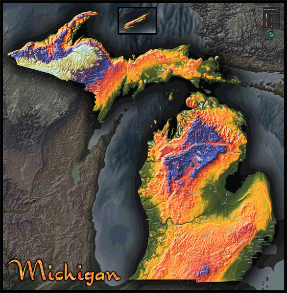
Michigan Topo Wall Map
This colorful and artistic map of Michigan is a topographical physical map like you've never seen before. This visually stunning map serves as both an artistic poster and a Michigan reference map combined into one splendid map. The sensational image of the map was created by using digital elevation data to produce a 3-D model of Michigan's terrain. The landscape is then colored according to elevation. The unique result is a stunning image of Michigan that is entirely accurate and incredibly detailed - even the smallest of hills and valleys are clearly visible. The state of Michigan looks especially intriguing when displayed with this topographical style. The variation in landforms and terrain throughout the state (especially in the Porcupine Mountains of the Upper Peninsula) is remarkably prominent in the map. While this map serves primarily as a physical map to visualize Michigan's terrain, the map also includes Michigan's major towns and cities. This addition adds usefulness to the Michigan map without cluttering it or detracting from Michigan's physical beauty. Whether you're looking for beautiful map art or a Michigan reference map, this Michigan map poster is guaranteed to satisfy and look spectacular when displayed on your wall. We offer this same map style for other states and countries too, so be sure to check them out. This map includes the following features:
- Topographical coloration of terrain
- Scale which matches color to corresponding elevation values
- Three-dimensional shaded relief
- Michigan cities and towns with population greater than 5000 (source: 2010 census)
- Legend
- Note: The purpose of this map is to provide a visual representation of Michigan's topography and landscape. In order to maintain a clean and uncluttered image, map detail is limited to towns and cities only.
The Wall Map of Michigan Topo is printed on 24lb. premium coated bond paper. It is also laminated on both sides using 3mm hot lamination, which protects your wall map and allows you to write on it with dry-erase markers.


Outlook Maps
Qty: 1