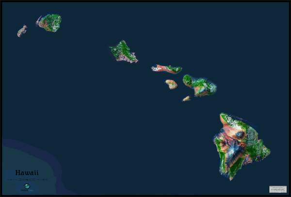
Hawaii Satellite Wall Map
This Hawaii Satellite Map dramatically displays the "Aloha State" as seen from outer space. The striking aerial view map was created from spectral data (satellite image data) taken from NASA's Landsat satellites which was then combined with 3-D shading to provide a natural looking satellite map that has three dimensional depth, helping to see natural terrain much more than the traditional "flat" satellite maps you're used to. Among the most fantastic and unique places in the world, the Hawaiian Islands look absolutely amazing when viewed from satellites in space. The lush jungles, rugged terrain, stark volcanic mountains, and numerous sandy beaches are all clearly visible. This beautiful Hawaii Satellite Map is extremely detailed too: each pixel of resolution in the printed map equates to just 150 ft (46 meters)! This super high resolution allows identification of urban cities, small towns, major roads, airports, and even large parks within cities. Details are more vivid and easier to see on larger map sizes, so we recommend ordering the largest map that will fit on your wall. Map labels were left off of the map so the satellite image appears more natural and uncluttered. This spectacular Hawaii satellite map will definitely provide hours of excitement: you'll feel like you're exploring the great state of Hawaii for the first time!
The Wall Map of Hawaii Satellite is printed on 24lb. premium coated bond paper. It is also laminated on both sides using 3mm hot lamination, which protects your wall map and allows you to write on it with dry-erase markers.


Outlook Maps
Qty: 1