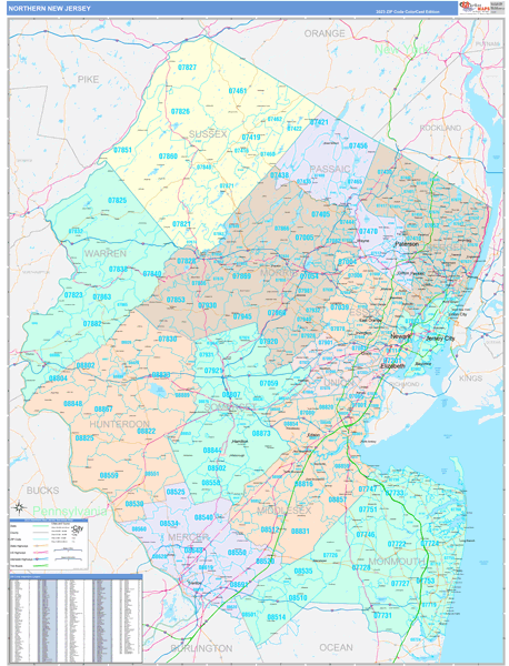
New Jersey Northern Wall Map
The Color Cast Style Northern New Jersey Wall Map is a multi-colored display that shades each geographic area with its own background color. It is an ideal choice for applications that benefit from quickly and easily distinguishing one County or Zip Code from the others. The Color Cast Style Wall Map of Northern New Jersey with highway detail also features distinct geographic color shading.
This New Jersey Northern wall map is laminated on both sides using 3mm hot lamination, which protects your map and allows you to write on it with dry-erase markers.
Wall Map
Map Sizes (inches)


Finishing Options

add to cart
add to cart
add to cart
add to cart
add to cart
add to cart
add to cart
add to cart
add to cart
add to cart
add to cart
add to cart
add to cart
add to cart
add to cart
add to cart

add to cart
add to cart
add to cart
add to cart
add to cart
add to cart
add to cart
add to cart
add to cart
add to cart
add to cart
add to cart
add to cart
add to cart
add to cart
add to cart
add to cart
add to cart
add to cart
add to cart
add to cart
add to cart
add to cart
add to cart
add to cart

Color Cast Style 2026
MarketMAPS
Qty: 1