Zoom
 Pan
Pan
Albany-Schenectady-Troy
Metro Area, NY Zip Code Wall Map
In Stock
by MarketMAPS

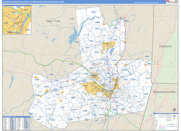
The Zip Code Albany-Schenectady-Troy Wall Map in the Basic Style clearly shows Zip Code boundaries along with other important map information. This popular style makes it easy to view and reference information about Albany-Schenectady-Troy Metro Area.
People select the Zip Code Basic Style because this Albany-Schenectady-Troy map:
- - Uses easy to read text labels to display Metro Area information.
- - Depicts shaded populated areas in Albany-Schenectady-Troy Metro Area.
- - Offers 3mm hot lamination on both sides for longevity.
- - Is perfect for including business locations and marking territories directly on the map.
In Stock
Choose Your
Wall Map
Wall Map
Choose Your
Map Sizes (inches)
Map Sizes (inches)
Delivered as FAST as Next Day!


Choose Your
Finishing Options
Finishing Options

36x48
48x64
60x80
72x96
90x120
108x144
Laminated Map
$125
add to cart
add to cart
$245
add to cart
add to cart
$375
add to cart
add to cart
$495
add to cart
add to cart
$745
add to cart
add to cart
$995
add to cart
add to cart
...with Wooden Rails
$175
add to cart
add to cart
$275
add to cart
add to cart
$495
add to cart
add to cart
$625
add to cart
add to cart
$995
add to cart
add to cart
$1195
add to cart
add to cart
...Mounted Maps
$375
add to cart
add to cart
$670
add to cart
add to cart
$945
add to cart
add to cart
$1120
add to cart
add to cart

...Magnetic Maps
$545
add to cart
add to cart
$870
add to cart
add to cart
$1195
add to cart
add to cart
$1620
add to cart
add to cart
Looking for other Finishing Options?
ReStickersBasic FramedExec. FramedPlastic RailsSynthetic Maps
Other Wall Map Finishing Options
ReStickers
$225
add to cart
add to cart
$325
add to cart
add to cart
$445
add to cart
add to cart
Unfinished
...Basic Framed
$425
add to cart
add to cart
$670
add to cart
add to cart
$995
add to cart
add to cart
$1220
add to cart
add to cart
Dark Oak
...Executive Framed
$545
add to cart
add to cart
$870
add to cart
add to cart
$1095
add to cart
add to cart
$1470
add to cart
add to cart
...Plastic Rails
$175
add to cart
add to cart
$275
add to cart
add to cart
$495
add to cart
add to cart
$625
add to cart
add to cart
$995
add to cart
add to cart
Paper Maps
$125
add to cart
add to cart
$245
add to cart
add to cart
$375
add to cart
add to cart
Synthetic Maps
$150
add to cart
add to cart
$295
add to cart
add to cart


X
Item Successfully Added to Your Cart
Albany-Schenectady-Troy
Metro Area Zip Code Wall Map $85.00
Metro Area Zip Code Wall Map $85.00
Basic Style 2026
MarketMAPS
Qty: 1