Zoom
 Pan
Pan
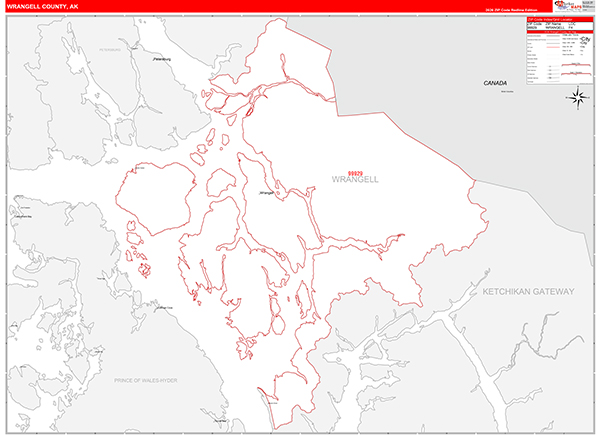
Wrangell-Petersburg Borough (County), AK Zip Code
Wall Map
In Stock
by MarketMAPS

The Red Line Style Wall Map is an easy to read display with basic map detail. It features all 5-Digit Zip Code numbers and boundaries within Wrangell-Petersburg Borough (County), AK as well as a clean white background that is essential for planning.
People purchase the Wrangell-Petersburg Borough (County), AK zip code map in the Red Line Style because:
- - Map details such as text, lines and numbers are clear and easy to read.
- - The Wrangell-Petersburg map is laminated and compatible with dry erase markers.
- - They can write, draw and mark distinct areas and locations on the map.
- - Any business details added to the map are easy to read on the red and white map.
In Stock
Choose Your
Wall Map
Wall Map
Choose Your
Map Sizes (inches)
Map Sizes (inches)
Delivered as FAST as Next Day!


Choose Your
Finishing Options
Finishing Options

36x48
48x64
60x80
72x96
90x120
108x144
Laminated Map
$125
add to cart
add to cart
$245
add to cart
add to cart
$375
add to cart
add to cart
$495
add to cart
add to cart
$745
add to cart
add to cart
$995
add to cart
add to cart
...with Wooden Rails
$175
add to cart
add to cart
$275
add to cart
add to cart
$495
add to cart
add to cart
$625
add to cart
add to cart
$995
add to cart
add to cart
$1195
add to cart
add to cart
...Mounted Maps
$375
add to cart
add to cart
$670
add to cart
add to cart
$945
add to cart
add to cart
$1120
add to cart
add to cart

...Magnetic Maps
$545
add to cart
add to cart
$870
add to cart
add to cart
$1195
add to cart
add to cart
$1620
add to cart
add to cart
Looking for other Finishing Options?
ReStickersBasic FramedExec. FramedPlastic RailsSynthetic Maps
Other Wall Map Finishing Options
ReStickers
$225
add to cart
add to cart
$325
add to cart
add to cart
$445
add to cart
add to cart
Unfinished
...Basic Framed
$425
add to cart
add to cart
$670
add to cart
add to cart
$995
add to cart
add to cart
$1220
add to cart
add to cart
Dark Oak
...Executive Framed
$545
add to cart
add to cart
$870
add to cart
add to cart
$1095
add to cart
add to cart
$1470
add to cart
add to cart
...Plastic Rails
$175
add to cart
add to cart
$275
add to cart
add to cart
$495
add to cart
add to cart
$625
add to cart
add to cart
$995
add to cart
add to cart
Paper Maps
$125
add to cart
add to cart
$245
add to cart
add to cart
$375
add to cart
add to cart
Synthetic Maps
$150
add to cart
add to cart
$295
add to cart
add to cart
X
Item Successfully Added to Your Cart
Wrangell-Petersburg Borough (County), AK Zip Code Wall Map
$85.00
Red Line Style 2026
MarketMAPS
Qty: 1