Zoom
 Pan
Pan
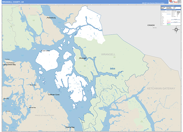
Wrangell-Petersburg Borough (County), AK
Carrier Route Wall Map
by MarketMAPS
In Stock

The Wrangell-Petersburg, AK Wall Map in the Basic Style is great for presentation. It offers traditional colors, standard map details and distinct carrier route boundaries.
People choose the Basic Style for their Wrangell-Petersburg Borough (County) Carrier Route Wall Map because:
- - The map details are clear and easy to read.
- - It displays up-to-date Carrier Route information for Direct Mail Marketing.
- - It is protected by 3mm lamination on both sides.
- - The map is ideal for use with dry erase markers.
In Stock
Choose Your
Wall Map
Wall Map
Choose Your
Map Sizes (inches)
Map Sizes (inches)
Delivered as FAST as Next Day!


Choose Your
Finishing Options
Finishing Options
36x48

48x64
60x80
72x96
90x120
108x144
Laminated Map
$125
add to cart
add to cart
$245
add to cart
add to cart
$375
add to cart
add to cart
$495
add to cart
add to cart
$745
add to cart
add to cart
$995
add to cart
add to cart
...with Wooden Rails
$175
add to cart
add to cart
$275
add to cart
add to cart
$495
add to cart
add to cart
$625
add to cart
add to cart
$995
add to cart
add to cart
$1195
add to cart
add to cart
...Mounted Maps
$375
add to cart
add to cart
$670
add to cart
add to cart
$945
add to cart
add to cart
$1120
add to cart
add to cart

...Magnetic Maps
$545
add to cart
add to cart
$870
add to cart
add to cart
$1195
add to cart
add to cart
$1620
add to cart
add to cart
Looking for other Finishing Options?
ReStickersBasic FramedExec. FramedPlastic RailsSynthetic Maps
Other Wall Map Finishing Options
ReStickers
$225
add to cart
add to cart
$325
add to cart
add to cart
$445
add to cart
add to cart
Unfinished
...Basic Framed
$425
add to cart
add to cart
$670
add to cart
add to cart
$995
add to cart
add to cart
$1220
add to cart
add to cart
Dark Oak
...Executive Framed
$545
add to cart
add to cart
$870
add to cart
add to cart
$1095
add to cart
add to cart
$1470
add to cart
add to cart
...Plastic Rails
$175
add to cart
add to cart
$275
add to cart
add to cart
$495
add to cart
add to cart
$625
add to cart
add to cart
$995
add to cart
add to cart
Paper Maps
$125
add to cart
add to cart
$245
add to cart
add to cart
$375
add to cart
add to cart
Synthetic Maps
$150
add to cart
add to cart
$295
add to cart
add to cart
You might also like this Wrangell-Petersburg (County), AK Wall Maps:
X
Item Successfully Added to Your Cart
Wrangell-Petersburg Borough (County), AK Carrier Route Wall Map
$85.00
Basic Style 2026
MarketMAPS
Qty: 1