Our Classroom Maps Are Updated Yearly!
Zoom
 Pan
Pan
;)
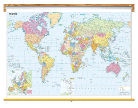
World Political Wall Map with Cities
Classroom Pull Down
In Stock
by Maps of World
$350
Size: 36x54in
Finishing: Spring Roller
Enhance your classroom walls with this brightly-colored Pull Down Wall Map of the cities of the world.
- This education map also includes:
- - International Boundaries
- - Roads
- - Cities
- - Major seaports, airports and country capitals
The World Political Map with Cities Classroom Pull Down is printed on 24lb. premium coated bond paper. It is also laminated on both sides using 3mm hot lamination, which protects your wall map and allows you to write on it with dry-erase markers. This laminated educational Pull Down Map is mounted to a secure Spring Roller ready to hang on any classroom wall.
In Stock
Delivered as FAST as Next Day!
Are Updated Yearly!
Delivered as FAST as Next Day.
GUARANTEED
1-888-434-6277
You might also like these other Classroom Pull Down Bundles:
X
Item Successfully Added to Your Cart
World Political Wall Map with Cities
Classroom Pull Down
$350
Classroom Pull Down
$350
Maps of World
Qty: 1