;)
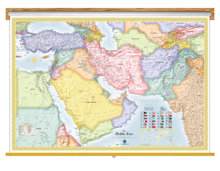
Middle East Political Wall Map
Classroom Pull Down
Breathtaking and educational, this Middle East Political Wall Map Classroom Pull Down is a gorgeous depiction of the geography of the Middle East region. With its bright colors, subtly shaded outlines, and classic map border, this Mideast map provides a classic elegance perfect for display. The shaded relief of mountains and terrain, which uses digital elevation data, gives the mountains a striking depth and a 3D appearance that makes them seem to jump off the page. The coverage area of this Middle East classroom map extends both eastward and westward beyond the traditional Middle East region to also include nations like Turkey, Egypt, Afghanistan, Pakistan, and much of India, which are usually not included in Middle East maps. This Middle East political wall map for schools is up-to-date and packed with content and geographic layers. More than three thousand labeled places are clearly shown, many of which won't even show up on other Middle East maps. The combination of detail and beauty makes this Middle East political map the ideal reference map for education.
- This map includes the following features:
- Countries, shown in multi-color
- National Capitals
- Cities, labeled to show relative size and importance
- 3-D Shaded Relief of Mountains and Terrain
- Water Features: Rivers, Lakes, Bays, Seas etc.
- Land Natural Features: Mountain Ranges, Deserts, Islands, etc.
- Peaks and Summits, labeled with elevation
- Major Highways, unlabeled
- Urban Areas
- Longitude/Latitude Gridlines
- Flags of all Middle East Nations
- Legend
The Middle East Political Classroom Pull Down Wall Map is printed on 24lb. premium coated bond paper. It is also laminated on both sides using 3mm hot lamination, which protects your classroom wall map and allows you to write on it with dry-erase markers. This laminated educational Pull Down Map is mounted to a secure Spring Roller ready to hang on any classroom wall.
Are Updated Yearly!
Delivered as FAST as Next Day.
GUARANTEED
1-888-434-6277
Classroom Pull Down
$350
Outlook Maps
Qty: 1