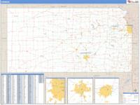
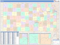
Kansas Wall Map
by Rand McNally
|

|
Our Rand McNally maps are designed for business and referential use, and offer high-quality cartography.
This map includes - State highways, federal highways, county highways
- County boundaries
- City shading
- Cities and towns
- Major waterways
- state/national parks
- Military installations, airports, and universities
This map is laminated on both sides using 3mm hot lamination, which protects your
map and allows you to write on it with dry-erase markers.
Item Code: Kansas
Date: 2007
|


;)