Zoom
 Pan
Pan
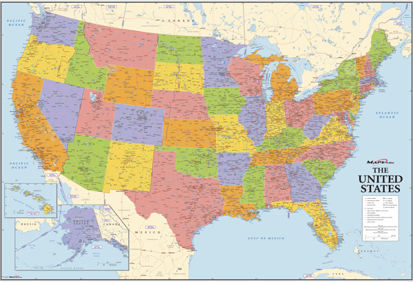
USA Political Wall Map
In Stock
by Maps.com
A very complete map of the United States. Vibrant colors, combined with an abundance of information makes this map suitable for use in business or reference.
This map includes the following details:
State Capitals
Primary Cities
Secondary Cities*
Some Towns*
US Interstates (numbered)
US Highways (numbered)
Major Freeways, Highways, and Toll Roads
Major Lakes & Rivers
Time Zones
Longitude/Latitude Graticule
Primary Cities
Secondary Cities*
Some Towns*
US Interstates (numbered)
US Highways (numbered)
Major Freeways, Highways, and Toll Roads
Major Lakes & Rivers
Time Zones
Longitude/Latitude Graticule
*Minimum population of 5,000. Most towns are displayed in less populated areas such as the Dakotas. In densely populated areas like Chicago, NY, and LA, only those cities with population amounts greater than 50,000 are displayed, due to space limitations.
The Wall Map of USA Political is printed on 24lb. premium coated bond paper. It is also laminated on both sides using 3mm hot lamination, which protects your wall map and allows you to write on it with dry-erase markers.
Item Code: USA WA
Your Selection:
Size:
33 x 48"
Unit Price:
$78
Finishing Option:
Laminated
In Stock
Your Options
Available Map Sizes
Delivered as FAST as Next Day!


Available Finishing Options

33 x 48"
44 x 64"
55 x 80"
66 x 96"
82 x 120"
99 x 144"
Laminated Map
Selected
Select
Select
Select
Select
Select
...with Wooden Rails
Select
Select
Select
Select
Select
Select
...Mounted Maps
Select
Select
Select
Select

...Magnetic Maps
Select
Select
Select
Select
Looking for other Finishing Options?
ReStickersBasic FramedExec. FramedPlastic RailsSynthetic Maps
Other Wall Map Finishing Options
ReStickers
Select
Select
Select
Unfinished
...Basic Framed
Select
Select
Select
Select
Dark Oak
...Executive Framed
Select
Select
Select
Select
...Plastic Rails
Select
Select
Select
Select
Select
Archival Paper
Select
Select
Select
Synthetic Maps
Select
Select
You might also like these USA Wall Maps:
X
Item Successfully Added to Your Cart
USA Political Wall Map
$85.00
Maps.com
Qty: 1