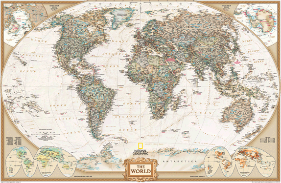
MapSales.com - world maps, country maps, continent maps wall maps Over 162,114 wall maps...
     ...delivered as FAST as Next Day!
1-888-434-6277
sales@mapsales.com
Business Wall Maps delivered for free via FedEx 2 Day
Shop for Your Wall Maps
International Wall Maps
  World Wall Maps
Continent Wall Maps
Country Wall Maps
United States Wall Maps
  USA Wall Maps
State Wall Maps
County Wall Maps
City Wall Maps
USA Regional Wall Maps
Metro Area Wall Maps
Topographic Wall Maps
Business Wall Maps
Zip Code Wall Maps
Custom Wall Maps
Wall Map Departments
  Antique Wall Maps
Canada Wall Maps
Custom Wall Maps
Education & Classroom
Gift Finder
Interior Décor Wall Maps
Discounted Bundles
Delivery Wall Maps
Specialty Wall Maps
  Mounted Maps
Maps on Spring Rollers
MapSales.com Newsletter
Our Publishers
MarketMAPS   National Geographic
GeoNova    GRAPHI-OGRE geoatlas
Hema Maps   Map Resources
UniversalMAP Thomas Bros. Maps
Rand McNally Hedberg Maps
Mapsco Maps.com Wide World of Maps
How can we help?
 
Other Great Sites
Home > World Wall Maps > World Political Map (antique tones)

World Political Map (antique tones)

World Political Map (antique tones)

Take a closer look at a great map! Use the
Choose Your Wall Map
Choose Your
Map Size
Delivered as FAST as next day!
 
Choose Your
Finishing Options

30x46

48x73

53x80

64x96

80x120

95x144
Laminated Map
$29.95
add to cart
$69.95
add to cart
$225
add to cart
$395
add to cart
$495
add to cart
$655
add to cart
... with Wooden
Rails
$60
add to cart
$110
add to cart
$275
add to cart
$455
add to cart
$555
add to cart
$725
add to cart
... on Spring
Rollers
$90
add to cart
$130
add to cart
$305
add to cart
$495
add to cart
   
Mounted Map
$160
add to cart
$220
add to cart
$385
add to cart
$595
add to cart
   
Magnetic Map
$260
add to cart
$350
add to cart
$525
add to cart
$895
add to cart
   

World Political Map (antique tones)

by National Geographic
National Geographic World map

This elegant, richly colored antique-style world map features the incredible cartographic detail that is the trademark quality of National Geographic. The map features a Tripel Projection which reduces distortion of land masses as they near the poles. Corner inset maps feature vegetation, land use and population density. This elegant map is also winner of the 2001 Premier Print Award from Printing Industries of America for 'a unique ability to create visual masterpieces.' It also is the winner of the 2002 Best Reference Map from the American Congress on Surveying & Mapping.

This map is printed on 24lb. premium coated bond paper. It is also laminated on both sides using 3mm hot lamination , which protects your map and allows you to write on it with dry-erase markers.

Item Code: World-Executive-Std_T

You might also like these Wall Maps:

World Political
Wall Map


Select this Map
World Deluxe Political
Wall Map


Select this Map
Back
 Return Policy | About Us | About Our Clients | Contact Us | Site Index | Help