Zoom
 Pan
Pan
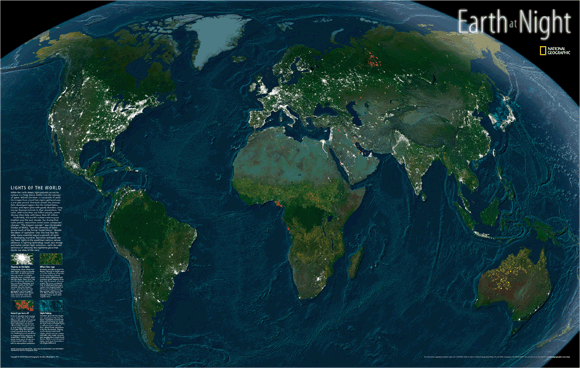
World at Night Wall Map
In Stock
by National Geographic
The World at Night Wall Map shows, in stunning detail, the lights of the Earth. This map is generated from satellite images on cloud-free nights for a one-year period of time. The World at Night Wall Map shows the white-hot lights of urban areas, the orange glow from forest fires, the red lights of natural gas burnoff, and blue lights where night fishing occurs.
The Wall Map of World at Night is printed on 24lb. premium coated bond paper. It is also laminated on both sides using 3mm hot lamination, which protects your wall map and allows you to write on it with dry-erase markers.
Item Code: Earth_At_Night
Your Selection:
Size:
32 x 47"
Unit Price:
$74
Finishing Option:
Laminated
In Stock
Your Options
Available Map Sizes
Delivered as FAST as Next Day!


Available Finishing Options

32 x 47"
43 x 63"
54 x 79"
64 x 95"
80 x 119"
96 x 143"
Laminated Map
Selected
Select
Select
Select
Select
Select
...with Wooden Rails
Select
Select
Select
Select
Select
Select
...Mounted Maps
Select
Select
Select
Select

...Magnetic Maps
Select
Select
Select
Select
Looking for other Finishing Options?
ReStickersBasic FramedExec. FramedPlastic RailsSynthetic Maps
Other Wall Map Finishing Options
ReStickers
Select
Select
Select
Unfinished
...Basic Framed
Select
Select
Select
Select
Dark Oak
...Executive Framed
Select
Select
Select
Select
...Plastic Rails
Select
Select
Select
Select
Select
Archival Paper
Select
Select
Select
Synthetic Maps
Select
Select
You might also like these World Wall Maps:
X
Item Successfully Added to Your Cart
World at Night Wall Map
$85.00
National Geographic
Qty: 1