Zoom
 Pan
Pan
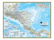
West Indies Wall Map
In Stock
by National Geographic
A detailed representation of the West Indies, this wall map contains insets with images of key points and descriptive information. Map includes the following features:
- Highways and major roads
- Capitals and other cities
- Airports
- Political boundaries
- Other points of interest, including volcanoes.
The Wall Map of West Indies is printed on 24lb. premium coated bond paper. It is also laminated on both sides using 3mm hot lamination, which protects your wall map and allows you to write on it with dry-erase markers.
Item Code: WestIndies
Your Selection:
Size:
32 x 48"
Unit Price:
$78
Finishing Option:
Laminated
In Stock
Your Options
Available Map Sizes
Delivered as FAST as Next Day!


Available Finishing Options

32 x 48"
43 x 64"
54 x 80"
64 x 96"
80 x 120"
96 x 144"
Laminated Map
Selected
Select
Select
Select
Select
Select
...with Wooden Rails
Select
Select
Select
Select
Select
Select
...Mounted Maps
Select
Select
Select
Select

...Magnetic Maps
Select
Select
Select
Select
Looking for other Finishing Options?
ReStickersBasic FramedExec. FramedPlastic RailsSynthetic Maps
Other Wall Map Finishing Options
ReStickers
Select
Select
Select
Unfinished
...Basic Framed
Select
Select
Select
Select
Dark Oak
...Executive Framed
Select
Select
Select
Select
...Plastic Rails
Select
Select
Select
Select
Select
Archival Paper
Select
Select
Select
Synthetic Maps
Select
Select
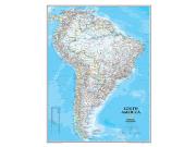
You might also like these Continent Wall Maps:
X
Item Successfully Added to Your Cart
West Indies Wall Map
$85.00
National Geographic
Qty: 1