Zoom
 Pan
Pan
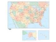
United States Political
Wall Map (Grayscale)
In Stock
by Map Resources
Continuing our trend in offering difficult-to-find wall maps, MapSales.com's latest line of USA wall maps delivers just the right amount of information for business or reference use. Using attractive colors and easy-to-read text, this wall map offers the following features:
Grayscale color scheme
Contains political sub-divisions (states & countries)
Capitals and cities names
Country names and international boundaries
Lakes and rivers
Albers Equal Area Conic Projection
Contains political sub-divisions (states & countries)
Capitals and cities names
Country names and international boundaries
Lakes and rivers
Albers Equal Area Conic Projection
The Wall Map of United States Political (Grayscale) is printed on 24lb. premium coated bond paper. It is also laminated on both sides using 3mm hot lamination, which protects your wall map and allows you to write on it with dry-erase markers.
Item Code: GPW2-US08
Your Selection:
Size:
36 x 38"
Unit Price:
$74
Finishing Option:
Laminated
In Stock
Your Options
Available Map Sizes
Delivered as FAST as Next Day!


Available Finishing Options

36 x 38"
48 x 50"
60 x 62"
72 x 74"
90 x 120"
108 x 144"
Laminated Map
Selected
Select
Select
Select
Select
Select
...with Wooden Rails
Select
Select
Select
Select
Select
Select
...Mounted Maps
Select
Select
Select
Select

...Magnetic Maps
Select
Select
Select
Select
Looking for other Finishing Options?
ReStickersBasic FramedExec. FramedPlastic RailsSynthetic Maps
Other Wall Map Finishing Options
ReStickers
Select
Select
Select
Unfinished
...Basic Framed
Select
Select
Select
Select
Dark Oak
...Executive Framed
Select
Select
Select
Select
...Plastic Rails
Select
Select
Select
Select
Select
Archival Paper
Select
Select
Select
Synthetic Maps
Select
Select
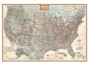
You might also like these USA Wall Maps:
X
Item Successfully Added to Your Cart
United States Political Wall Map (Grayscale)
$85.00
Map Resources
Qty: 1