Zoom
 Pan
Pan
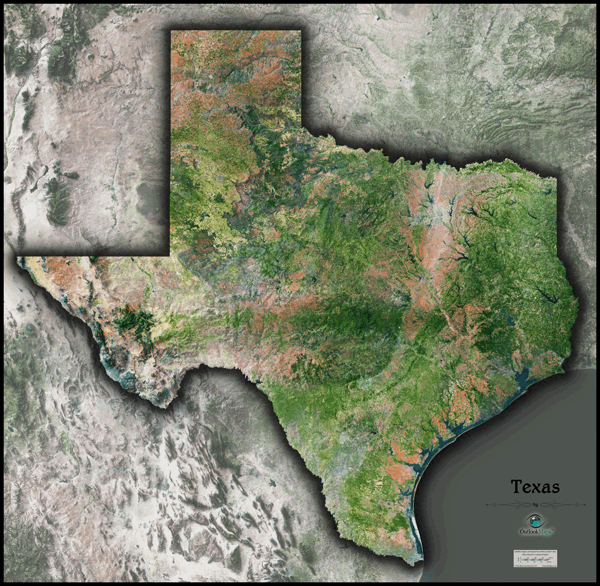
Texas Satellite Wall Map
In Stock
by Outlook Maps
This stunning Texas satellite map displays Texas's natural beauty as seen from space. The striking map combines images obtained from NASA's Landsat satellites with 3-D shading to provide an image of Texas unlike anything you've ever seen.
This map includes the following features:
- High resolution satellite imagery: 1 printed pixel represents 360 ft (110 m)
- Clear visibility of individual crop fileds, rivers, urban areas, and even large airports
- Sleek shading of the outline of the state
- Labels were intentionally omitted to create a natural, uncluttered image
- Order the largest size which will fit your wall to enhance the visibility of detail
The Wall Map of Texas Satellite is printed on 24lb. premium coated bond paper. It is also laminated on both sides using 3mm hot lamination, which protects your wall map and allows you to write on it with dry-erase markers.
Item Code: TX-Satellite
Your Selection:
Size:
41 x 42"
Unit Price:
$83
Finishing Option:
Laminated
In Stock
Your Options
Available Map Sizes
Delivered as FAST as Next Day!


Available Finishing Options
41 x 42"
48 x 50"
60 x 62"
Laminated Map
Selected
Select
Select
...with Wooden Rails
Select
Select
Select
...Mounted Maps
Select
Select
Select
...Magnetic Maps
Select
Select
Select
Looking for other Finishing Options?
ReStickersBasic FramedExec. FramedPlastic RailsSynthetic Maps
Other Wall Map Finishing Options
ReStickers
Select
Select
Select
Unfinished
...Basic Framed
Select
Select
Select
Dark Oak
...Executive Framed
Select
Select
Select
...Plastic Rails
Select
Select
Select
Archival Paper
Select
Select
Select
Synthetic Maps
Select
Select
You might also like these State Wall Maps:
X
Item Successfully Added to Your Cart
Texas Satellite Wall Map
$85.00
Outlook Maps
Qty: 1