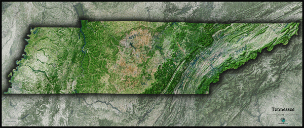
Tennessee Satellite Wall Map
This Tennessee Satellite Map dramatically displays the "Volunteer State" as seen from outer space. This stunning aerial view map was created from spectral data (satellite image data) taken from NASA's Landsat satellites which was then combined with 3-D shading to provide a natural looking satellite map that has three dimensional depth helping to see terrain much more than the "flat" satellite maps you've seen. This map really brings out the natural beauty and contrasting areas of Tennessee, from the ridges of the Appalachians in the east all the way to the Mississippi Valley in the west, and in between a wide range of landforms, forests, agriculture land, and river valleys. Man-made urban areas and farmland can clearly be distinguished from the wilderness. This splendid Tennessee Satellite Map is also incredibly detailed: each pixel of resolution in the map is equal to just 142 ft (43 meters)! This super high resolution allows identification of urban cities, small towns, crop fields, rivers, major roads, ponds, airports, and even large parks within cities. You'll see more vivid details on large sized maps, so we recommend ordering the largest map that will fit on your wall. Map labels were intentionally omitted to create a pure, uncluttered look. This spectacular satellite image is guaranteed to provide hours of enjoyment as you explore all the natural and man-made wonder visible in this Tennessee satellite map. This Tennessee Satellite Wall Map includes the following features:
- High resolution satellite imagery: 1 printed pixel represents 142 ft (43 m) of actual distance
- Sleek shading of Tennessee's outline
- Three dimensional shaded relief
- Legend with scale bar
- Clear visibility of cities, roads, rivers, parks, fields of agriculture, and much more
The Wall Map of Tennessee Satellite is printed on 24lb. premium coated bond paper. It is also laminated on both sides using 3mm hot lamination, which protects your wall map and allows you to write on it with dry-erase markers.


Outlook Maps
Qty: 1