Home > Outlook Maps > State Maps > Pennsylvania Satellite Wall Map
Zoom In
Zoom
Close Window
Pan
Pennsylvania Satellite Wall Map

Pennsylvania Satellite Wall Map

In Stock
by Outlook Maps

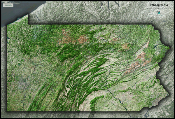
This Pennsylvania Satellite Map dramatically displays the "Keystone State" as seen from outer space. The striking aerial view map was created from spectral data (satellite image data) taken from NASA's Landsat satellites which was then combined with 3D shading of the landscape to provide a natural looking satellite map that has three-dimensional depth to see terrain much more than the "flat" satellite maps you've seen. Being one of the more rugged and mountainous states, it's no surprise that this satellite map really brings out the natural beauty of Pennsylvania. The Appalachian Mountains are really vivid as they streak across most of Pennsylvania. There's also a clear contrast between Allegheny Plateau to the west of the Appalachians and the lower and flatter lands to the east. It's very easy to distinguish wooded areas and mountains from developed urban areas and agriculture lands in this map. This gorgeous Pennsylvania Satellite Map is incredibly detailed too: each pixel of resolution in the printed map represents 117 ft (36 meters)! This high resolution allows easy identification of urban cities, small towns, crop fields, rivers, roads, ponds, airports, and even golf courses and parks within cities. You'll see details more clearly on large sized maps, so we recommend ordering the largest map which can fit on your wall. Labels were intentionally omitted to create a pure, uncluttered look. This spectacular satellite image will no doubt provide hours of enjoyment as you explore all the natural and man made wonder visible in this Pennsylvania satellite map. This Pennsylvania Satellite Wall Map includes the following features:

  • High resolution satellite imagery: 1 printed pixel represents just 117 ft (36 m)
  • Sleek shading of Pennsylvania's outline
  • Three dimensional shaded relief
  • Legend with map scale bar
  • Clear visibility of cities, roads, parks, rivers, fields of agriculture, and more
  • The Wall Map of Pennsylvania Satellite is printed on 24lb. premium coated bond paper. It is also laminated on both sides using 3mm hot lamination, which protects your wall map and allows you to write on it with dry-erase markers.

    Item Code: Pennsylvania Satellite
    Your Selection:
    Size:
    34 x 50"
    Unit Price:
    $83
    Finishing Option: Laminated
    In Stock
    Your Options
    Available Map Sizes
    Delivered as FAST as Next Day!
    Available Finishing Options
    34 x 50
    34 x 50"
    44 x 64
    44 x 64"
    55 x 80
    55 x 80"
    Laminated Wall Maps
    Laminated MapLearn More
    Selected
    Select
    Select
    Maps on Wooden Rails
    ...with Wooden Rails
    Learn More
    Select
    Select
    Select
    Mounted Wall Maps
    ...Mounted Maps
    Learn More
    Select
    Select
    Select
    Magnetic Wall Maps
    ...Magnetic Maps
    Learn More
    Select
    Select
    Select
    Looking for other Finishing Options?
    View Other Finishing Options
    Other finishing options
    ReStickersBasic FramedExec. FramedPlastic RailsSynthetic Maps
    Other Wall Map Finishing Options
    Hide Other Finishing Options
    Map ReStickers
    ReStickers
    Learn More
    Select
    Select
    Select
    Unfinished Framed Wall Maps
    Unfinished
    Select Frame Color
    Basic Framed Wall Maps
    ...Basic Framed
    Learn More
    Select
    Select
    Select
    Dark Oak Executive Framed Wall Maps
    Dark Oak
    Select Frame Color
    Executive Framed Wall Maps
    ...Executive Framed
    Learn More
    Select
    Select
    Select
    Plastic Rail Wall Maps
    ...Plastic Rails
    Learn More
    Select
    Select
    Select
    Archival Paper
    Archival Paper
    Learn More
    Select
    Select
    Select
    Synthetic Maps
    Synthetic Maps
    Learn More
    Select
    Select
    You might also like these State Wall Maps:
    Pennsylvania Wall Map
    • Professional looking
    Wall Map
    • Excellent for Wall Map
    displays
    More Info
    Pennsylvania Wall Map
    • Multi-colored Wall Map
    • Ideal for presentation
    More Info
     
    X
    100% Satisfaction Guaranteed! 100%Satisfaction Guaranteed!
    Delivered as
    FAST as Next Day!
    Pennsylvania Satellite Wall Map
    Item Successfully Added to Your Cart
    Pennsylvania Satellite
    Wall Map
    $85.00

    Outlook Maps

    Qty: 1
    View Cart Continue Shopping