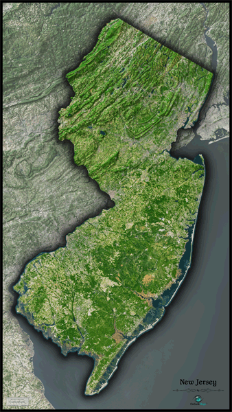
New Jersey Satellite Wall Map
This New Jersey Satellite Map dramatically displays the "Garden State" as seen from outer space. This stunning aerial image was created from spectral data (satellite image data) taken from NASA's Landsat satellites which was then combined with 3-D shading. This provides a vivid, natural looking satellite map that has three dimensional depth, helping to see terrain much more than the "flat" satellite maps you've seen before. This map really captures the natural beauty of New Jersey, from the coastal plains to the rugged ridges of the Appalachian Mountains in the north. Farm lands, wooded areas, and urban areas are very easy to distinguish. This gorgeous New Jersey Satellite Map is extremely detailed too: each printed pixel of resolution in the map represents just 60 ft (18 meters)! This ultra-high level of resolution allows easy identification of parks, golf courses, airports, bridges, roads, ponds, streams, individual crop fields, and even large buildings. Detail is more visible on large sized maps, so we recommend ordering the largest map that will fit on your wall. Map labels were left off to create a satellite image that has a pure and uncluttered appearance. This spectacular satellite image is guaranteed to provide hours of enjoyment as you explore all the natural and man-made wonder visible in this New Jersey satellite map.
This New Jersey Satellite Wall Map includes the following features:
- High resolution satellite imagery: 1 printed pixel represents just 60 ft (18 m)
- Sleek shading of New Jersey's state outline
- Three dimensional shaded relief
- Legend with map scale bar
- Clear visibility of cities, roads, rivers, parks, fields of agriculture, and much more
The Wall Map of New Jersey Satellite is printed on 24lb. premium coated bond paper. It is also laminated on both sides using 3mm hot lamination, which protects your wall map and allows you to write on it with dry-erase markers.


Outlook Maps
Qty: 1