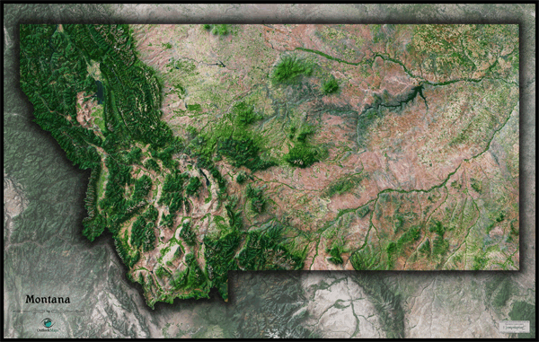
Montana Satellite Wall Map
This Montana Satellite Map spectacularly displays the "Treasure State" as it's seen from outer space. The stunning aerial view map was created from spectral data obtained from NASA's Landsat satellites which was then combined with 3D shading of the landscape to provide a natural looking satellite map that has three-dimensional depth which helps to make out terrain much more than the "flat" satellite maps you've seen. The Rocky Mountains of eastern Montana really come to life in this map. The map also accentuates the stark contrast between Montana's plains and mountains. Specific Montana mountain ranges within the Rockies, such as Lewis Range, Bitterroot Mountains, Cabinet Mountains, Little and Big Belt Mountains, Crazy Mountains, and Absaroka Range are all visible and easy to distinguish. This beautiful Montana Satellite Map is incredibly detailed too: each pixel of resolution in the map equates to just 212 ft (65 meters)! This high resolution allows urban cities, small towns, crop fields, rivers, lakes, major highways, and more to show up clearly. Detail is more visible on large sized maps, so we recommend ordering the largest Montana satellite map that will fit on your wall. Labels were intentionally omitted to create a natural, uncluttered look. This amazing satellite image is guaranteed to provide hours of enjoyment as you explore all the natural and man-made wonder visible in this Montana satellite map. This Montana Satellite Wall Map features the following:
- High resolution satellite imagery: 1 printed pixel represents just 212 ft (65 m)
- Sleek shading of Montana's outline
- Three dimensional shaded relief
- Legend with scale bar
- Clear visibility of cities, roads, rivers, fields of agriculture, and more
The Wall Map of Montana Satellite is printed on 24lb. premium coated bond paper. It is also laminated on both sides using 3mm hot lamination, which protects your wall map and allows you to write on it with dry-erase markers.


Outlook Maps
Qty: 1