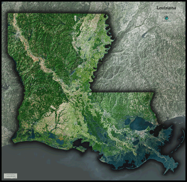
Louisiana Satellite Wall Map
This Louisiana Satellite Map dramatically displays the "Pelican State" as seen from outer space. This stunning aerial image was created from spectral data (satellite image data) obtained from NASA's Landsat satellites which was then combined with 3-D shading. This provides a natural looking satellite map that has 3 dimensional depth which helps to make out natural terrain much more than the traditional "flat" satellite maps you're used to. The natural beauty and variation of land throughout Louisiana is very pronounced in the satellite map. Forested areas and lowland swamps are visible and easy to distinguish from urban areas and farmland. This gorgeous Louisiana Satellite Map is extremely detailed too: each pixel of resolution in the printed map is equal to 142 ft (43 meters)! This high resolution allows urban cities, small towns, crop fields, rivers, major roads, ponds, airports, and even large parks within cities to be viewed clearly. You'll see more vivid details on large sized maps, so we recommend ordering the largest map which can fit on your wall. Labels were intentionally omitted to create a pure, uncluttered look. This spectacular Louisiana satellite map is guaranteed to provide hours of excitement: you'll feel like you're exploring the great state of Louisiana for the first time! This Louisiana Satellite Wall Map features the following:
- High resolution satellite imagery: 1 printed pixel represents just 142 ft (43 m)
- Sleek shading of Louisiana's outline
- Three dimensional shaded relief
- Legend with map scale bar
- Clear visibility of cities, roads, parks, rivers, crop fields, and much more
The Wall Map of Louisiana Satellite is printed on 24lb. premium coated bond paper. It is also laminated on both sides using 3mm hot lamination, which protects your wall map and allows you to write on it with dry-erase markers.


Outlook Maps
Qty: 1