Home > Outlook Maps > State Maps > Kansas Satellite Wall Map
Zoom In
Zoom
Close Window
Pan
Kansas Satellite Wall Map

Kansas Satellite Wall Map

In Stock
by Outlook Maps

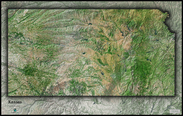
This Kansas Satellite Map dramatically displays the "Sunflower State" as seen from outer space. The stunning aerial image was created from spectral data (satellite image data) taken from NASA's Landsat satellites which was then combined with 3D shading of the landscape to provide a natural looking satellite map that has 3 dimensional depth helping to distinguish terrain much more than traditional "flat" satellite maps. The natural beauty of the great plains really comes to life in this Kansas satellite map. The farm lands, prairies, subtle hills, and numerous rivers that streak across the state are very prominently shown. Specific hilly regions such as the Smoky Hills, Flint Hills, Red Hills, and Blue Hills are all visible in the map. This splendid Kansas Satellite Map is incredibly detailed too: each printed pixel of resolution in the map is equal to 153 ft (47 meters)! This high resolution allows identification of urban cities and towns, crop fields (including circular irrigated fields), rivers, major highways, lakes, airports, and even large parks within cities. You'll see details more clearly on large sized maps, so we recommend ordering the largest map which can fit on your wall. Labels were intentionally omitted to create a natural, uncluttered look. This spectacular Kansas satellite map will definitely provide hours of excitement: you'll feel like you're exploring the great state of Kansas for the first time!

The Wall Map of Kansas Satellite is printed on 24lb. premium coated bond paper. It is also laminated on both sides using 3mm hot lamination, which protects your wall map and allows you to write on it with dry-erase markers.

Item Code: Kansas Satellite
Your Selection:
Size:
33 x 52"
Unit Price:
$83
Finishing Option: Laminated
In Stock
Your Options
Available Map Sizes
Delivered as FAST as Next Day!
Available Finishing Options
33 x 52
33 x 52"
41 x 64
41 x 64"
52 x 80
52 x 80"
Laminated Wall Maps
Laminated MapLearn More
Selected
Select
Select
Maps on Wooden Rails
...with Wooden Rails
Learn More
Select
Select
Select
Mounted Wall Maps
...Mounted Maps
Learn More
Select
Select
Select
Magnetic Wall Maps
...Magnetic Maps
Learn More
Select
Select
Select
Looking for other Finishing Options?
View Other Finishing Options
Other finishing options
ReStickersBasic FramedExec. FramedPlastic RailsSynthetic Maps
Other Wall Map Finishing Options
Hide Other Finishing Options
Map ReStickers
ReStickers
Learn More
Select
Select
Select
Unfinished Framed Wall Maps
Unfinished
Select Frame Color
Basic Framed Wall Maps
...Basic Framed
Learn More
Select
Select
Select
Dark Oak Executive Framed Wall Maps
Dark Oak
Select Frame Color
Executive Framed Wall Maps
...Executive Framed
Learn More
Select
Select
Select
Plastic Rail Wall Maps
...Plastic Rails
Learn More
Select
Select
Select
Archival Paper
Archival Paper
Learn More
Select
Select
Select
Synthetic Maps
Synthetic Maps
Learn More
Select
Select
You might also like these State Wall Maps:
Kansas Wall Map
• Professional looking
Wall Map
• Excellent for Wall Map
displays
More Info
Kansas Wall Map
• Multi-colored Wall Map
• Ideal for presentation
More Info
 
X
100% Satisfaction Guaranteed! 100%Satisfaction Guaranteed!
Delivered as
FAST as Next Day!
Kansas Satellite Wall Map
Item Successfully Added to Your Cart
Kansas Satellite Wall Map $85.00

Outlook Maps

Qty: 1
View Cart Continue Shopping