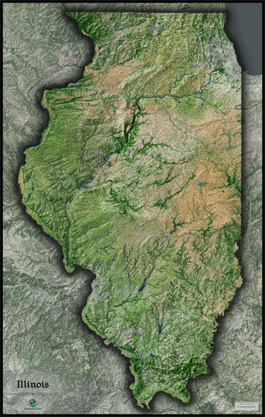
Illinois Satellite Wall Map
This Illinois Satellite Map dramatically displays the "Prairie State" as seen from outer space. This stunning aerial image was created from spectral data obtained from NASA's Landsat satellites which was then combined with 3D shading of the landscape. This provides a natural looking satellite map that has three-dimensional depth helping to make out terrain much more than the traditional "flat" satellite maps you're used to. The natural beauty of Illinois' fertile farm land, river valleys, subtle hills, and forested areas really come to life in this map. It's very easy in this map to distinguish between natural wooded areas, urban development, and agriculture lands. This gorgeous Illinois Satellite Map is incredibly detailed too: each pixel of resolution in the map is equal to just 139 ft (42 meters)! This high resolution allows urban cities, small towns, crop fields, rivers, major roads, ponds, airports, and even large parks within cities to be viewed clearly. You'll see more details on large sized maps, so we recommend ordering the largest Illinois satellite map which can fit on your wall. Labels were left off of the map so the satellite image appears more pure and uncluttered. This spectacular Illinois satellite map is guaranteed to provide hours of excitement: you'll feel like you're exploring the great state of Illinois for the first time!
The Wall Map of Illinois Satellite is printed on 24lb. premium coated bond paper. It is also laminated on both sides using 3mm hot lamination, which protects your wall map and allows you to write on it with dry-erase markers.


Outlook Maps
Qty: 1