Zoom
 Pan
Pan
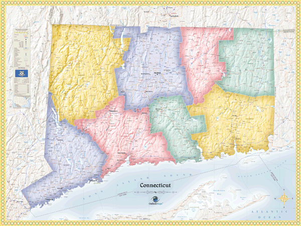
Connecticut Political Wall Map
In Stock
by Outlook Maps
This colorful wall map of Connecticut is completely up to date, easy to read, and loaded with detail - literally thousands of labels are shown. Whether for business, education, or personal travel, this Connecticut wall map is sure to meet your mapping needs and look spectacular on display.
This map includes the following features:
- Cities and Towns, categorized by population level
- State Capital
- County Names and Boundaries shown in multi-color
- State Borders
- Interstates and Highways, labeled with Route Numbers
- Local Roads, mostly un-labeled
- 3-D Shaded Relief of Terrain
- Water Features: Rivers, Lakes, Bays, Dams, etc.
- Land Features: Mountain Ranges, Hilly Areas, Islands, etc.
- All Commercial Airports, labeled with 3-Letter FAA Code
- Peaks and Summits with Elevation Data (including State's Highest Point)
- Major Universities
- Ski Locations
- Federally Protected Natural Areas
- Military Installations
- Major Attractions and Points of Interest
- Longitude/Latitude Gridlines
- Legend, with State Information and Statistics
The Wall Map of Connecticut Political is printed on 24lb. premium coated bond paper. It is also laminated on both sides using 3mm hot lamination, which protects your wall map and allows you to write on it with dry-erase markers.
Item Code: CT-Political
Your Selection:
Size:
36 x 48"
Unit Price:
$83
Finishing Option:
Laminated
In Stock
Your Options
Available Map Sizes
Delivered as FAST as Next Day!


Available Finishing Options
36 x 48"
48 x 64"
60 x 80"
72 x 96"
Laminated Map
Selected
Select
Select
Select
...with Wooden Rails
Select
Select
Select
Select
...Mounted Maps
Select
Select
Select
Select

...Magnetic Maps
Select
Select
Select
Select
Looking for other Finishing Options?
ReStickersBasic FramedExec. FramedPlastic RailsSynthetic Maps
Other Wall Map Finishing Options
ReStickers
Select
Select
Select
Unfinished
...Basic Framed
Select
Select
Select
Select
Dark Oak
...Executive Framed
Select
Select
Select
Select
...Plastic Rails
Select
Select
Select
Select
Archival Paper
Select
Select
Select
Synthetic Maps
Select
Select
You might also like these State Wall Maps:
X
Item Successfully Added to Your Cart
Connecticut Political
Wall Map $85.00
Wall Map $85.00
Outlook Maps
Qty: 1