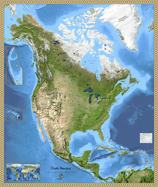
North America Satellite Wall Map
This stunning satellite map of North America is a perfect combination of satellite imagery and geographic information. The satellite imagery was obtained by NASA during the month of May, a time of colorful earth tones and visible snow in the north and on mountain peaks. The image is further enhanced by adding shading to create a stunning 3-D effect that helps to visualize mountains, plains, plateaus, hills, and valleys much more than traditional ''flat'' satellite imagery. All major landforms of North America are clearly visible: from the Canadian tundra, to the Rocky Mountains, to Midwestern farm land, to the deserts of Mexico, to the lush jungles of Central America. This North America satellite map also includes several geographic layers (both physical and political) and just the right amount of detail to be useful yet uncluttered. The natural colored border adds the finishing touch to ensure that this map will look spectacular on display. You'll likely spend hours exploring the North America's natural beauty as seen from outer space!
This map includes the following features:
- NASA Satellite Imagery, enhanced with 3-D shading
- Country Borders and Names
- National Capitals
- States and Provinces for USA and Canada
- State/Provincial Capitals
- Major Cities
- Water Features: Rivers, Lakes, Bays, Seas etc.
- Land Natural Features: Mountain Ranges, Deserts, Islands, etc.
- Peaks and Summits, labeled with elevation
- Bathymetry (Ocean Floor) Shading
- Legend
The Wall Map of North America Satellite is printed on 24lb. premium coated bond paper. It is also laminated on both sides using 3mm hot lamination, which protects your wall map and allows you to write on it with dry-erase markers.


Wall Map $85.00
Outlook Maps
Qty: 1