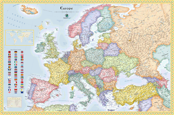
Europe Political Wall Map
This Europe political wall map is a gorgeous depiction of the geography of the European continent. With its bright colors, subtly shaded outlines, and classic map border, this Europe map provides a classic elegance perfect for display. The shaded relief of mountains and terrain, which is accompished digitally using actual elevation data, gives the mountains striking depth and a three-dimensional appearance that makes them seem to jump off the page. This Europe political wall map is up-to-date and packed with content and features. More than FIVE THOUSAND labeled places are clearly shown, many of which won't even show up on other Europe maps, making this map ideal for business, travel, or education. The combination of detail and beauty makes this Europe political map the perfect reference map to display in any classroom, office, or home!
This map includes the following features:
- Countries, shown in multi-color
- National Capitals
- Cities, labeled to show relative size and importance
- 3-D Shaded Relief of Mountains and Terrain
- Water Features: Rivers, Lakes, Bays, Seas etc.
- Land Natural Features: Mountain Ranges, Deserts, Islands, etc.
- Peaks and Summits, labeled with elevation
- Major Highways, unlabeled
- Major Ferry Routes
- Urban Areas
- Longitude/Latitude Gridlines
- Flags of all European Nations
- Legend
The Wall Map of Europe Political is printed on 24lb. premium coated bond paper. It is also laminated on both sides using 3mm hot lamination, which protects your wall map and allows you to write on it with dry-erase markers.


Outlook Maps
Qty: 1